![]()


This walk: 2011-12-28. Grimstone & Sortridge Leat, Plaster Down, Samford Tor or Little Pew Tor, Sampford Spiney Parish boundary stones, Heckwood Quarry, feathers and tare, broken trough, Feather Tor, clapper bridge, Beckamoor or Windy Post Cross, bullseye stone, abandoned apple crusher, millstone or feeding trough?, Pew Tor boundary marks, WW2 bomb craters.
Walk details below - Information about the route etc.

The Grimstone & Sortridge Leat, after crossing the road from the car park. The leat was to supply Grimstone manor in the 14th Century, also Sortridge Consols mine with its 24 ft. water wheel. The leat has more bullseye delivery stones than any other on Dartmoor (see Windy Post Cross photos below). By the time it gets to Windy Post (see below), it has served Shillapark, Tor Quarry, Merrivale dwellings and farm.
The car park was on the edge of Plaster Down, an area requisitioned at the outbreak of WW2, later to become an American military hospital, it was last used to house Asians thrown out of Uganda at short notice by the dictator Idi Amin in 1972. 80,000 were thrown out of which 30,000 held British passports and many of them came to this country.

An early look up the track towards Pew or Pu Tor.

A closer view, as we passed around the flanks of the tor towards Heckwood Tor. Actually, this is not Pew Tor-proper but Samford Tor or Little Pew Tor, at SX 531 732.

Even Jess, the dog, paid attention!

The disused quarry inside Samford Tor ..... most of this granite went into Tavistock Pannier Market .....

Another view.

Looking for Sampford Spiney church (visited on 27 June 2007).

Crossing the leat.

Sampford Spiney Parish boundary stone, at SX 53619 73468

Matthew on a discarded piece of dressed granite in Heckwood Quarry ..... visited previously on 3rd Nov. 2010 .....

Heckwood Quarry ..... a good place to explain the use of feathers and tares ......
Photos taken from 7th April 2010 .....
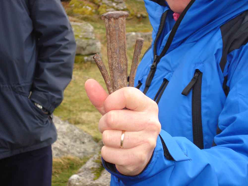
Original feathers and tare, as used at the Merrivale Quarry .....
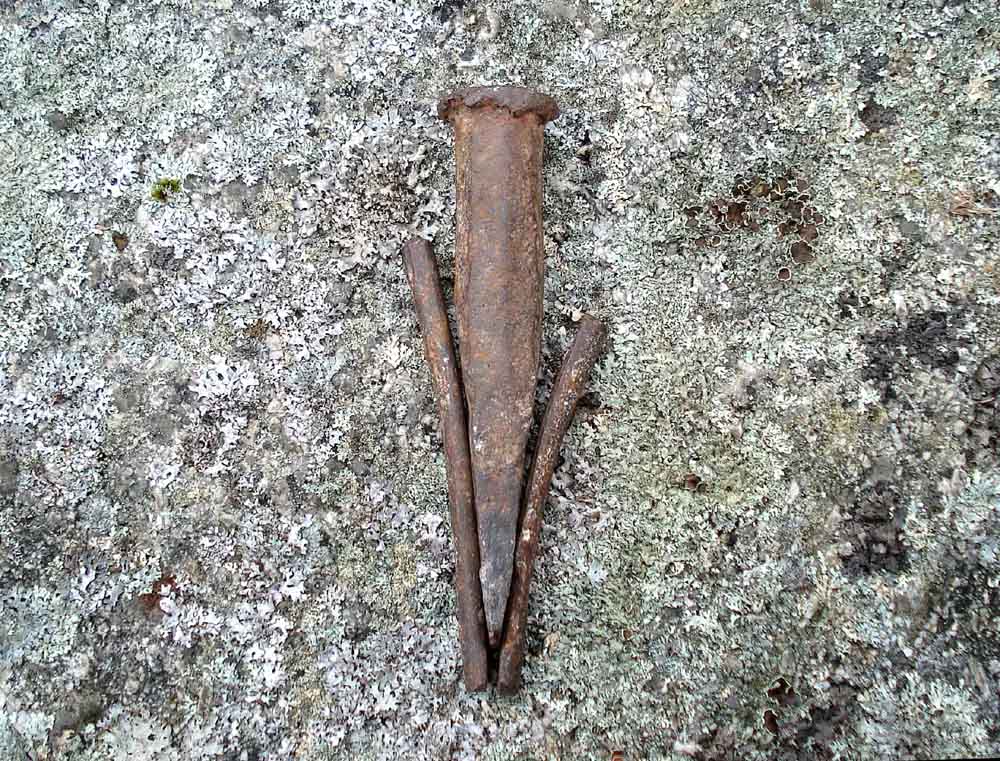
..... and again. The collective item was inserted into a hole that had been drilled into the granite - in fact, a line of such holes were drilled in a row in the rock and each hole was fitted with a set of feathers and tares. The feathers are the slightly curved half-round steel pieces and the tare is the central "chisel" that was gently tapped in, in sequence along the line being worked on to apply gradual pressure to the rock until it split.

A tree in outline near Heckwood Quarry.

A nearby rockpile, Heckwood Quarry.

Vixen Tor, with Great Mis Tor behind.

Broken trough at SX 53742 73903: this is actually a half-trough or perhaps a fireplace that was fractured across the near corner, first seen 3rd Nov. 2010.

Feather Tor, SX 534 741.

Clapper bridge, the path to Pew Tor.

A view to Great Staple Tor, with a pony finding a wind break.

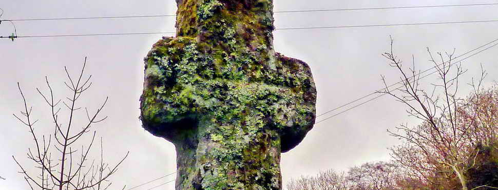
Beckamoor or Windy Post Cross, on the old Tavistock-Ashburton track (these being two important stannary towns). The cross is chamfered all round and bears an Ordnance Survey benchmarck on the face that is visible in this and the next photograph ..... (see detail photo later)

Another view.

A few steps away is the Grimstone & Sortridge Leat, running from Merrivale (at top right in photo) towards Moortown (to left in photo), where another bullseye stone provides potwater to that farm. There are a series of at least four bullseye stones after the Windy Post one: see five bulls-eye stones in this area in this walk: 2010-4-8 PewTor.

The bullseye stone.

As previous photo.

Showing the leat, on the left, and the run-off from the bullseye stone to the right. The dotted white line indicates the approximate position of a stone that shows signs of being cut by both the feather and tare method and the wooden wedge method (detail photo below).

General view of Windy Post Cross and the leat .....

An incised OS benchmark lays between the two horizontal lines on the shaft of the cross, with a horizontal line above and the broad government arrow below.

Stone showing feather and tare marks (on upper edge, running bottom right to top left) and wedge and groove marks (failed?, full of moss on the right, sloping surface).

Discussion as to whether this is an abandoned apple crusher, millstone or feeding trough? This close to SX 53447 74103 - the actual position has been lost in a computer problem.

Closer view.

Clapper bridge.

Approaching Pew Tor.
Pew Tor was being plundered of its granite in the mid-1800's. Meetings in Tavistock resulted in representations to the Duchy to put in some restraints.

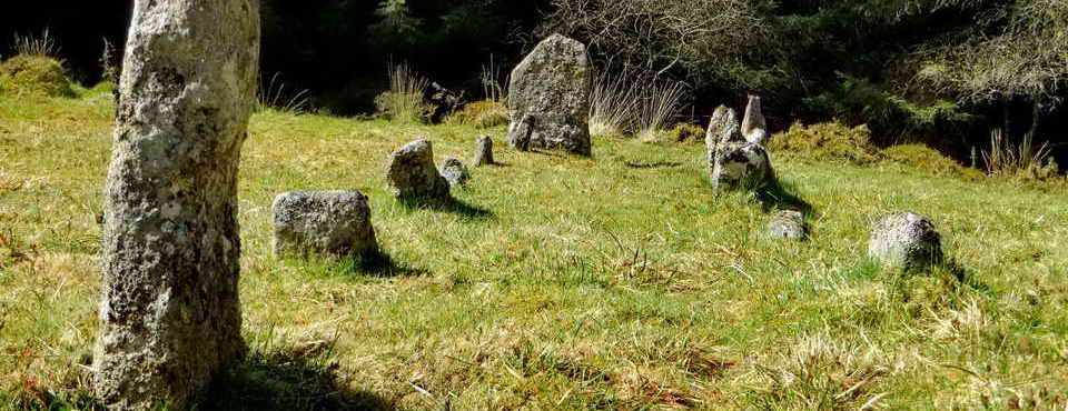
One of nine boundary marks (from 1847) 10-inch diameter, quartered circles around the base of Pew Tor, inside which stone was not allowed to be taken. These are described by Dave Brewer (2002) Dartmoor Boundary Markers, Halsgrove, pp. 249-251.

One of the four later boundary marks on Pew Tor (from 1896): a 6-inch diameter quartered circle with holes drilled where the lines meet. These marks delimited an enlarged "no-take" area as an effort to preserve the tor from the stonemasons. This marker is at SX 53347 73445, the south-east corner.
From the Dave Brewer book (2002) .....
" ...... These are even smaller than the 1847 ones, only six inches in diameter and difficult to find, in fact one still eludes the most diligent searches for it. When Helen Harris wrote her article (Nineteenth Century Granite Working on Pew Tor and Staple Tor, Western Dartmoor, T.D.A. 1981) only two of the four marked stones had been recorded, but since that time the one at the north-west corner of the protective limit has been found. This stone is marked with the symbol both on its horizontal and vertical faces, and is near to the small quarry. The author did hear that the one at the south east corner was found in the early nineties, but no confirmation was forthcoming".
From Helen Harris (1981), Nineteenth Century Granite Working on Pew Tor and Staple Tor, Western Dartmoor. Rep. Trans. Devon Ass. Advmnt. Sci. 113, 21-51, December 1981 .....
"On 30 December, 1896 it was reported that �Mr Duke has had marks cut in some natural fixed stones to indicate new protective limits of Pew Tor, each mark being a circle with five holes about an inch deep to distinguish them from the original marks made by a cross within a circle'105 (see Fig. 3). Of the four marks, which are slightly smaller (roughly 6 inches in diameter) and less conspicuous than those of 1847, the ones on the south-west (see Plate I lib) and south-east corners have been found, but the other two are so far not located. Possibly they are obscured by encroachment of grass growth or lichen."
This definitely states that the south-west and south-east markers are recorded.
With the north-west marker being found near the small quarry, it is the north-east marker that is missing. It is unlikely to have been removed and is therefore probably overgrown, as was the south-east one, almost totally covered with grass except for one drilled hole.
I and others spent a lot of time searching for the markers in 2010, finding all except the north-east one, which, after calculation from the original 1896 sketch map in Dave Brewer's book, should lay somewhere around SX 53345 73527.
Further research at end-Dec 2011, on the sketch map reproduced in the Harris paper (Fig. 3): three viable approaches to the missing marker ......
| From known marker | Distance | Bearing |
| SX 53347 73445, south-east outer marker | 80.5 metres | 25.5� |
| SX 53285 73473, inner marker | 181.5 metres | 78� |
| SX 53275 73485, inner marker | 178 metres | 91� |
The distance between the south-east and north-east outer markers of 400 links on the map converts (100 links = 1 chain = 22 yards = 20.1168 metres) to 80.46 metres.
There is no indication of magnetic variation. An error of 1� over 100 metres gives a lateral deviation of 1.7 metres.
It should be noted that the position of markers in the plotted scatter diagram below of known grid references does not follow the shape of their outline in the old sketch map. In fact, the map can be quite misleading although it must be said that it led to our finding of the three known outer markers.
If you find the missing north-east outer marker, please let me know!

The diagram above presents the grid references of all the markers - including the missing north-east marker shown here at top right as a calculated position. The diagram derives from a spreadsheet chart, plotted as "northings" against "eastings". The numbers are from GPS records made in 2010, accurate to � 2 metres. The nine inner markers (from 1847) are shown by the small diamond symbols and the later, outer markers (from 1896) are shown by the larger triangles. The square symbols mark the two Sampford Spiney Parish boundary stones at SX 53198 73431 and SX 53307 73435. North is at the top of the diagram.
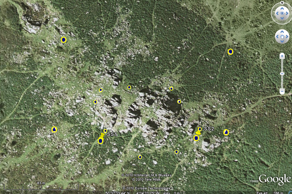
Google Earth image with overlain boundary marks from the Excel chart. The two "map pins" show the Sampford Spiney boundary stones.

Foreground, WW2 bomb crater made when fleeing German pilots dumped bombs on the moor, one of two here.

Side view of a bomb crater.

Sampford Spiney parish boundary stone at SX 53198 73431.

Old cart track ruts from where stonemasons used to load granite.

The other parish boundary stone by the tor, at SX 53307 73435 .....

Closer view; note how the lighting shows off the lettering compared to the previous SS stone, three photos above!

Looking back at Pew Tor.
MAP: Red = GPS satellite track of the walk.
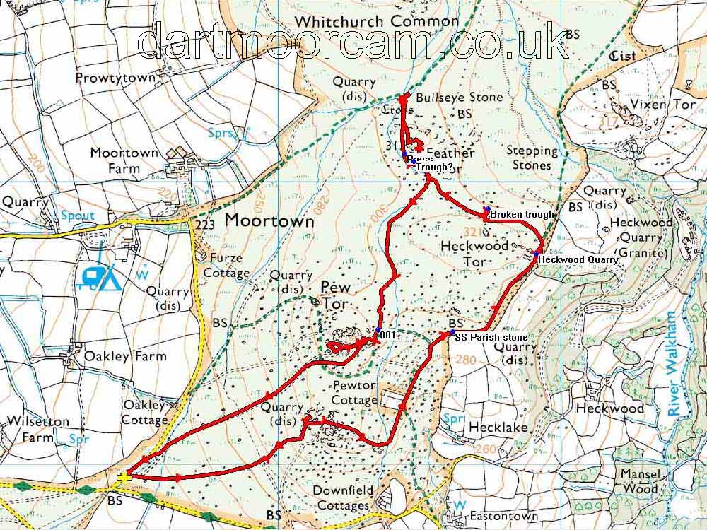
Ordnance Survey © Crown copyright 2005. All rights reserved. Licence number
100047373.
Also, Copyright © 2005, Memory-Map Europe, with permission.
The walk is probably most easily approached via the road from the church in Whitchurch (the south-eastern area of Tavistock), following signs to Moortown but parking before getting there on the roadside below Pew Tor. There is roadside parking in the area of the yellow cross on the map, which is located at SX 52527 73058.
Statistics
Distance - 5.8 km / 3.6 miles.
All photographs on this web site are copyright ©2007-2016 Keith Ryan.
All rights reserved - please email for permissions