![]()


This walk: 2018-12-13. Devonport leat, clapper bridge, leat monitoring station, Cross Gate cist, tinners' fougou, Leathertor Farm, potato cave, River Meavy, Leather Tor Bridge, ancient ford, Riddipit Steps stepping stones, Riddipit Farm longhouse, Riddipit Tin Mill, 2nd potato cave - with luminous moss, mortar stone, adit, Riddipit Gert, Keaglesborough Mine, lower and upper dressing floors, wheel pits, leat bank, feathers & tare stone. .
Walk details below - Information about the route etc.
Previous walks in this area: 22 Jul. 2011, 26 Jun. 2013, 13 Oct. 2015, 25 Jan. 2017
Reconnaissance walks: 19 Nov. 2018, 26 Nov. 2018, 30 Nov. 2018
Google Satellite map + GPS track of the walk

Norsworthy Bridge over the River Meavy, at "the far end" of Burrator Reservoir. A part of the car park is seen across the river and the track up to Crazy Well Pool .....

A near-river level view of the single-arch bridge .....

A barrier to prevent animals gaining access to the lake area?

The small gate in the centre of this photograph gives access to today's walk. It is a few yards back over the bridge from the car park. A few yards inside the gate is a ruined "blowing house" .....

A ruined "blowing house" (probably just a tin mill with no equipment for smelting) is recorded at SX 56732 69416, this being Norsworthy Bridge Mill on the Legendary Dartmoor - Tin Mills web page (allowing for a small variation in the GPS coordinates) ...... The significance of the year 1750 is that this is an "old" tin mill: this was the year when tin production finally ceased on Dartmoor - true underground mining started later.

Looking down on the tin mill site, beside the River Meavy.
Devon & Dartmoor HER - MDV12736 - TIN MILL in the Parish of Walkhampton

A view of the ascending path through the woods.

Approaching Devonport Leat .....

Devonport Leat, clapper bridge and an old leat monitoring station .....

A setup where water flow was once monitored.

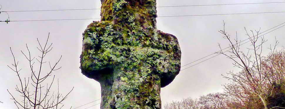
Looking towards Cross Gate, where there is an old cross, possibly incorporating part of the missing Leathertor Cross; the wooden fencing on the right is around Cross Gate cairn and cist .....

The Cross Gate cairn and its cist, at SX 5631 6953, are described by J. Butler (1994), Dartmoor Atlas of Antiquities III, The South West. 45.17 Leather Tor South cairn and cist, pages 51-52. This is described as a well-preserved cairn and cist, first recorded in 1935. The robbers' trench came in from the south-east, displacing the end stone downhill where it is now partly covered by the capstone .....

Closer view. "Kistvaen - A stone coffin, from
from the Celtic cist, a chest, and maen, stone, v being
used as a mutation of m."
Source: Crossing's Guide to Dartmoor,
2nd edition 1912, reprinted 1990, page 22.

Image © J Butler 1994. Reproduced by kind permission (ref. 29
Sept. 2012)

Approaching Leathertor Farm, gate and stile on the left. The signpost is seen next below ..... and down the slope on the right is the fougou.

The signpost .....

I have seen this signpost many times over the years since 1970 and I always thought I knew what it said! Quite clearly it says: PUBLIC FOOTPATH DEVONPORT LEAT / COUNTY ROAD CROSS GATE and down the road is Leathertor Bridge, obviously, but what does it actually say?

PUBLIC BRIDLEWAY OLDER BRIDGE / COUNTY ROAD CROSS GATE. Older Bridge is at SX 5981 7055, out past Crazy Well Pool where the old Abbot's Way crosses Devonport leat. Presumably the bridge was built when the leat was built (around 1801) so that the old track could still be used without hindrance.

The famous Dartmoor Treacle Mine, hidden until recent tree felling. The entrance is marked by the white "v". It is requested that we do not disabuse Wikipedia of their belief that this place is fictitious .......... this is found down the slope below Leathertor Farm. Look down the slope for the biggest tree stump near the river and the next stump downriver i.e. to rhe right. The mine entrance is hidden in the slope, between the two stumps .....BATS - Please note, bats sometimes use these caves. All bats are totally protected in the UK and it is illegal to disturb them or even photograph them without a license. Body heat and camera flashes can be very harmful to them. If you see a bat, you should leave immediately.
BATS - Please note, bats sometimes use these caves. All bats are totally protected in the UK and it is illegal to disturb them or even photograph them without a license. Body heat and camera flashes can be very harmful to them. If you see a bat, you should leave immediately .....

Closer view .....

Alternatively, the fougou (Cornish for "cave" or vooga in "Devon") at SX 56721 69774: a tinners' cache, dug into a bank where they would keep tools overnight to save carrying them long distances. It can be viewed from the Norsworthy Bridge-to-Leather Tor Bridge track at SX 56772 69746 .....

Fougou internal view, note the granite slabs forming the roof, making this a man-made cave (for tools) rather than the more usual potato cave, the latter normally being dug into growan ("rotted" granite). In this photograph, there is water in the fougou. The dimensions are 11-feet deep, 3-feet wide, 4-feet high, with the entrance being just 2½-feet high (Hemery, High Dartmoor, p.124). There is a traditional potato cave just 50 metres away on the track below Leathertor Farm.
Devon & Dartmoor HER - MDV3474 - Fogou or Tinners Cache to south of Leathertor

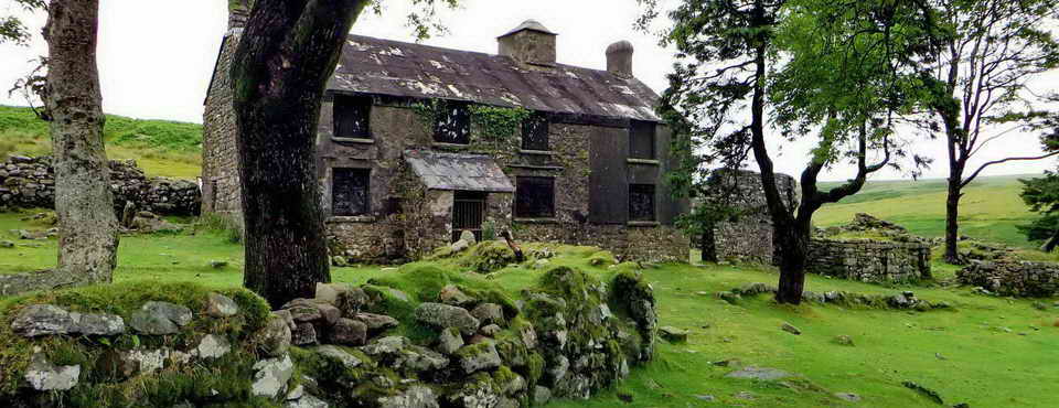
Leathertor Farm, at SX 5668 6980, first recorded in Bailiff's Accounts for the Manor of Dartmoor in 1362 regarding the renting of land at Leddertorre. A farm was first recorded in 1511. The last tenant was William Lillicrap who abandoned the farm in 1924. Some occupants were also tinners. Source: Paul Rendell (2007) Exploring Around Burrator, The Dartmoor Company, Okehampton, pages 20 and 55. The more modern buildings, above the track to the leat, were once West Leathertor .....
Leathertor Farm on the 1840 Walkhampton tithe map - the location of the fougou is indicated by the small rectangular feature in plot 852, just east of the old entrance into West Leathertor.
Devon & Dartmoor HER - MDV102653 - Barn at Leather Tor Farmstead, Walkhampton - constructed 1873, two walls stand north-east of the house.

Notice. Click the image to see a larger version.

Note the "broad and narrow" stonework at the quoins (external angles of the walls) .....
Devon & Dartmoor HER - MDV102651 - Leather Tor Farmhouse, Walkhampton - modern one, built 1870
Devon & Dartmoor HER - MDV102659 - West Leathertor Farmhouse, Walkhampton - on the slope at the northern end of the site, lying directly opposite the former East Leathertor Farmhouse.

A view around the corner .....

Near the buildings, up the slope, is this old rain gauge enclosure, shown on the Revised 1906 25-inch Ordnance Survey single sheet map ..... also on OS 25-inch 1892-1914 Series

Rain collecting vessel in situ. Shown on Waymarking.com.

Unidentified lichens on the fence rail.

A feature located around the back of the ruined farm buildings, or accessed by going up the track past the ruins and cutting back, up to the left. One authority has described this as "two granite plinths which may once have been the supports for a cider press": Source: Mike Brown (2001) Guide to Dartmoor, CD-ROM, Dartmoor Press, Grid Square 5667 6982. I am inclined to disagree and suggest this is the base for a large, mounted sharpening stone, the bottom of which could run through water in the trough, making it a wet stone (not to be confused with whet, an old word that means to "sharpen"). I have provided the horse-power for a similar stone - but with an iron strap frame and without the trough, when my father wanted to sharpen his axe - around 1956-1964!

Looking across the track that goes to Devonport Leat, at the old buildings of the farm, once part of West Leathertor, beside the Cross Gate-Older Bridge track .....
Devon & Dartmoor HER - MDV102663 - East Leather Tor Farmhouse, Walkhampton

As above.

About 50 metres down the road towards Leather Tor Bridge, at SX 5671 6981, a potato cave, 32 x 7 x 8 ft high. It is described by Eric Hemery, High Dartmoor, page 126. It would have been used for storing root crops, such as potatoes and swedes - no doubt for their pasties!

Closer view .....

Closer again .....

The interior of the "cave", showing it is dug into growan or the ground and not constructed of stone.
Devon & Dartmoor HER - MDV12733 - Potato Cave or Hull, Leather Tor Farm, Walkhampton

Leathertor Bridge, at SX 5688 6996. Walkhampton Parish Council decided on 20th June 1833 to build a bridge over Riddipit Stream (nowadays, the River Meavy) at this spot (this is the site of the Riddipit Steps stepping stones crossing place). At the next meeting the following month (25th July) it was resolved to accept a tender from George Worth and Wm. Mashford for £26.10s. This is a little more elaborate than most clapper bridges in that it has parapets. Source: Eric Hemery, High Dartmoor, page 126. Apparently, this was the last clapper bridge to be built on Dartmoor (Johnies Meanderings, 20th August 2012).

Looking up-stream .....

Fungi on a tree stump beside a "blurry" Leathertor Bridge (at top left). Probably Glistening Inkcap, Coprinus micaceous (also Link-2) - commonly found as clusters on deciduous tree stumps (and dead roots). Possibly Fairy Inkcap, Coprinellus disseminatus - but these are found in "swarms" on deciduous tree stumps and are perhaps a paler colour. Sources: (1) Roger Phillips (2006), Mushrooms, Macmillan, London, p. 260; and (2) Paul Sterry & Barry Hughes (2009), Collins Complete Guide to British Mushrooms and Toadstools, Harper Collins Publishers, London, p. 220 .....

Older fungi lower down the same stump .....

Undersurface of the cap of an older individual, "going inky". These photographs were taken on 19th Nov, on 26th Nov. there was no sign of these fungi, not even withered remains.

Another view of the bridge .....

Looking down on the parapet, some stones are secured with iron straps .....

Looking from the other side of the river ..... the central feature is the old ford .....

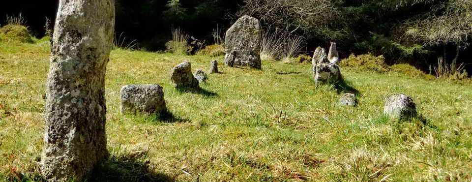
The seven stepping stones of the old Riddipit Steps are still to be seen, four in situ and three displaced by floods .......... ah, but which stones?!

The track junction seen when coming from Leathertor Bridge: left goes to Riddipit and the bridlepath along the river out to the open moor; right goes to Keaglesborough Mine, Raddick Lane, Crazy Well Pool and beyond - including Older Bridge.

The site of Riddipit farm beside Riddipit Lane (the link is to the 1840 tithe map). Hemery (p.127) notes alternative names are Ritthy Pit, Riddy Pit, Reedapit (1611), possibly to do with rushes, rishes or reeds. There were two houses here, shown on the 1840 tithe map - the remains of one longhouse are seen at the right edge of this photograph and the second one is seen across the clearing, down by the track. There are other ruined buildings, possibly barns, animal sheds or labourers' dwellings.
Riddipit Stream rises above the site and crosses the track in a granite conduit.
Crossing's Guide, p.100: Riddy Pit, there are stones with hollows in them (i.e. mortar stones), now in the paving of the track, a little beyond this view up the track. Close by, is an old wall, in the nearby hedge is a stone with a cavity on each side. Another curious stone with a round top and a piece of iron leaded into it is probably the upper stone of a crushing mill: this was never found by Hemery.
First recorded 1564, abandoned by 1871 when the enclosures were incorporated into Leather Tor Farm. Source: Paul Rendell (2007) Exploring Around Burrator, The Dartmoor Company, pages 31 and 57 ......
Devon & Dartmoor HER - MDV12839 - Reddipitt Farm, deserted site north-east of Leather Tor Bridge

Lower gable end wall of the longhouse (animal shippon) with a slit window .....

Looking upslope along the length of the longhouse. I measured the house at 24.4 x 5.33 metres (80 x 17.5 feet), using a 50-metre tape .....
Devon & Dartmoor HER - MDV66644 - Southern building within Riddipit Farmstead, Walkhampton - south longhouse

Looking across the site towards the second house seen on the tithe map surveyed in 1839 and approved in 1840.
Devon & Dartmoor HER - MDV66643 - Northern building within Riddipit Farmstead, Walkhampton - north longhouse

Riddipit Tin Mill right beside the track, at SX 57020 70162 ..... Described as a blowing house, but with no trace of a leat, launder bank or wheel pit, three necessary signs for a blowing house or tin mill, therefore probably a cart shed for the farm (Hemery p.128). However, the field behind this hedge is called "Mill Park" in the tithe apportionments (Plot 930)**. Also, the remains an old mortar stone is to be found here under the leaves and debris - but mortar stones are found widespread in the area .....
** To find Plot 930 in the Apportionments, look at the Walkhampton Tithe Map, scroll down to the map and click the blue PDF link. Then, use CTRL+F (i.e. hold down the Ctrl key and press the F key) and enter 930 in the search box that appears in your browser, normally at top right. "930" should appear highlighted halfway down the screen.
Devon & Dartmoor HER - MDV5021 - Stamping mill at Riddipit

Close view of a broken mortar stone in the "blowing house".

Stile into Riddipit potato cave, which is just out of sight at the top right..

The big potato cave at SX 57104 70336. RN Worth (1967) Worth's Dartmoor, David & Charles, page 417, describes it as a potato cave (always dug into growan) but Eric Hemery (1983) High Dartmoor, Robert Hale, London, page 129, argues that it shows signs of corbelling (as used in beehive huts, never seen in potato caves) and is in fact a cache (or vooga / fougou) for miners' tools from the Keaglesborough (Kekelles Burrowghe) Tin Mine .....
Devon & Dartmoor HER - MDV12841 - Riddipit hull 700 metres west-south-west of the northern end of Raddick Lane - potato cave

The entrance ..... built of stone ..... the following photographs of luminous moss were taken from the walk on 26 June 2013, because there seemed to be no moss when doing reconnaissance walks for this walk, too late in the year?

Flash photograph of the interior of the cave, about "35 feet deep" (Mike Brown (2001) Guide to Dartmoor, CD-ROM, Dartmoor Press, Grid Square 5710 7031).

Non-flash photograph of luminous moss or goblin's gold (presumably Schistozega pennata). Source: Norman Baldock & John Walters (2008) The Wildlife of Dartmoor, pages 115 and Index .....

Luminous moss, close-up .....

As previous photograph: the moss has round, lens-like cells that reflect light, presumably to maximise what little light there is in dark places, so as to maximise the photosynthetic process by which it produces sugars for energy to power its life processes.

View from the rear of the cave, natural light ..... note the restricted zone inside the cave entrance where there is enough natural light for green plant life.

Flash photograph inside the cave looking out. Note the granite door jambs and lintel, with a gate hanger visible in the left jamb.

Walking up the track from beside the River Meavy, approaching the entrance into the Keaglesborough Mine area (ahead, to the left, before reaching Raddick Lane) ..... the adit is down on the left (in the gert) after going through the entrance. The old access to the adit is blocked off with large boulders, seen in the extreme left of the photograph .....
KEAGLESBOROUGH MINE
The earliest reference to tinworking on this site is in a deed from 1538, where it is called Kekylsburgh. There is also a mention in a Walkhampton Manor court roll dated 1565 of Kekellas Burrowghe Mill. There are other references in deeds etc.
Keaglesburrowe Sett, “Keagles Burro also Lambards Park” (1748-65) and again (1811-20), another mention in 1820 uses “Lambers Parks Alies Kegales Borough” (= alias)
and later Keagles Burrow Mine. Source: Mike Brown (2001) Guide to Dartmoor, CD-ROM, Dartmoor Press, Grid Square 573 701.Tin mining started with men following alluvial deposits up streams and rivers and then digging into veins/lodes with pits and openworks (gerts or beams) into the hills. An Openwork in the nearby Newleycombe valley (Kingsett Gert) was first mentioned in 1505 (then, a long time in dispute), with a later date of 1639 (i.e. more than 140 years working). Ref. Phil Newman (1998), The Dartmoor Tin Industry - A Field Guide, Chercombe Press, Newton Abbot, p.8.
Early tin workings, while being a large industry in medieval times, finally ceased production by 1750 (Newman, Ibid, p.55).
In the late 1700s and 1800s, workings started going underground - with drainage effected by adits, horizontal tunnels driven into hillsides to let water run out of the workings e.g. Keaglesborough and Eylesborough.

General view of the adit in Keaglesborough Gert, at SX 57220 70074 .....
Devon & Dartmoor HER - MDV12842 - Adit at Keaglesborough Mine 850 metres north-east of Norsworthy Bridge

Turning around and looking down the mining gert ..... "Riddipit openworks. Part of Keaglesborough Mine" .....
Devon & Dartmoor HER - MDV42444 - OPEN CUT in the Parish of Walkhampton.....

Closer view of the adit .....

Inside the entrance .....

Further in, around to the left ..... camera stretched in from outside .....
PASTSCAPE MONUMENT NO. 1461629 - Leat to Keaglesbourough Mine from the River Meavy below Hart Tor (with a feeder from Hart Tor Brook) that ran down the valley left side above a steep tinners' cliff. This leat is depicted in Butler Vol. 3, Map 46, p.87.

Keaglesborough Mine, no other details recorded
Dartmoor Archive image used with permission
See this
image online at Dartmoor Archive

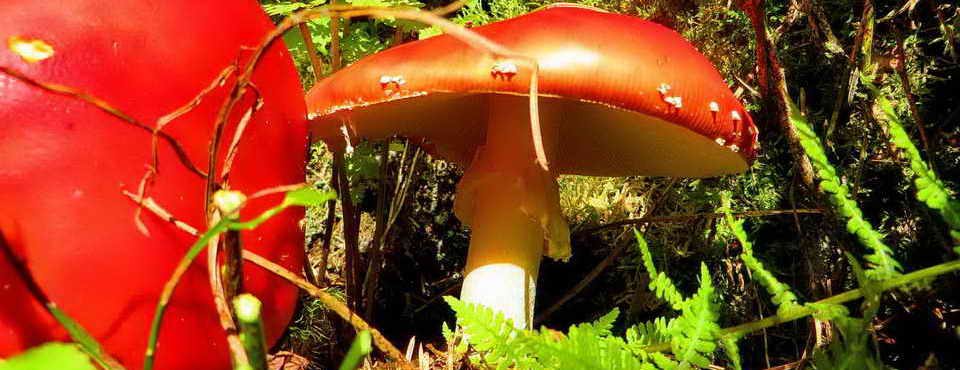
Yellow Brain fungus, aka golden jelly fungus, the yellow trembler and witches' butter, Tremella_mesenterica, frequently found on dead gorse.

Small wheelpit at SX 57290 70100, on the lower dressing floor. There are two "dressing floors" on this site, these being areas where mined rock is treated to concentrate the tin by crushing (under iron "stamps" falling againt mortar stones) to separate the tin-bearing rock from other rock of no value. The end of the leat that powered the waterwheel is probably the raised grassy area seen towards the top right in the photograph .....
This wheel was operating in 1801; length of wheelpit - 6.2 metres (20 feet) with a double-sided dressing floor, rectangular buddles. Source: Newman, Landscape, p.53 (see below for full reference).
Devon & Dartmoor HER - MDV35575 - Keaglesborough Mine

The leat embankment on the lower dressing floor .....

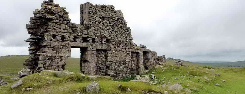
Big shaft at SX 57339 70077: with Leather Tor immediately behind and Sharpitor to the right ..... this is looking down the slope to where we entered the area .....

Today's group, enjoying the forecast "Feels like 3°C", keep smiling, folks!

Upper dressing floor - looking up the tailrace to the large wheelpit, with the raised embankment that brought the water to the waterwheel (via a launder) behind .....

Large wheelpit, SX 57381 70118 ..... this wheel was operating in 1830; length of wheelpit 9 metres (30 feet) with a double-sided dressing floor and rectangular buddles. Source: Newman, Landscape, p.53 (see below for full reference).

Looking along the large wheelpit and down the tailrace .....

Looking across the wheelpit to the far side of which is the silted up settling pit ..... beyond that is the area where there were two square buddles .....

Remains of one of the buddles .....

Raised embankment that carried the leat towards the waterwheel.
Reference
Phil Newman (2017), Mining for Tin on
Dartmoor in the Eighteenth to Twentieth Centuries: The Landscape Legacy.
In: Phil Newman (Ed), The Tinworking Landscape of
Dartmoor in a European Context, 27-51. Dartmoor Tinworking
Research Group.

Google Earth image of the Keaglesborough Mine area. Copyright: Image from Google Earth (c) 2018.
An aside .....
Tinning was important on Dartmoor from about 1150 and throughout the Middle Ages. Stannary records show that in the busiest period, 1515-1538, the "average" output of white tin metal presented annually for coinage was about 500,000 lbs i.e. 223 tons. Thus, over this 24 years, this would have been 5,357 tons. If a mould stone produced ingots that weighed about 1 cwt then this means 107,143 ingots were produced. It is believed that not all tin was presented for coinage and taxation. Source - interpretation of data in: Tom Greeves (2017),The World of the Dartmoor Tinner: An Historical Context 12th to 20th Century. In: Phil Newman (Ed), The Tinworking Landscape of Dartmoor in a European Context, 1-14. Dartmoor Tinworking Research Group.
Web page listing tin mills in the Norsworthy area

Tare and feathers stone, beside the track at SX 56990 69490, where someone drilled the stone and inserted sets of feathers, separated by hammering in a tare (metal chisel piece) to apply steady pressure until the rock cracked, which it did in part ..... this method of cutting granite was introduced around 1800 AS .....

Abandoned feathers and tare .....

As above. Link to a page about splitting granite; another page with photos
Click HERE to see a 160 MB, 17-minute video of the process of splitting granite.
Click HERE to see a smaller, poorer resolution, 64 MB version (45 seconds to download e.g. on BT Broadband) - this is best seen as a small image.
The split comes at 16:37 minutes!
MAP: Red = GPS satellite track of the walk.
 © Crown copyright 2016 Ordnance
Survey
Licence number 100047373
© Crown copyright 2016 Ordnance
Survey
Licence number 100047373
Also, Copyright © 2005, Memory-Map Europe, with permission.
This walk was reached by driving from Yelverton to Dousland, turning right beside the Burrator Inn towards Meavy, and then left on passing the last house, over the cattle grid to the far end of the reservoir. Do not go over the dam. Two car parks are indicated by yellow crosses on the map.
Statistics
Distance - 4.78 km / 2.97 miles
All photographs on this web site are copyright
© Keith Ryan.
All rights reserved - please
email for permissions