|
F11 - Full screen F11 - Normal view Home & Contents |
|
"Alt" +
� |
This walk: 2007-11-15 - Harford Moor Gate - hut circles - Hangershell Rock - cairn - Cist 1 - Spurrell's Cross - Glasscombe Ball - more cairns - stone row - Glasscombe Corner - stone rows - Long Barrow - Ball Gate - Three Barrows - Sharp Tor - Piles Gate - well-preserved cist - plus other views, on a beautiful day
Walk details below - Information about the route etc.

Hut circle, one of eight in the group between the car park and the reservoir at the start of the walk.

Looking back at the hut circle area (at SX 64435 59323) after crossing Butter Brook

View approaching Hangershell Rock, across the bridle path, at approx SX 65485 59363 (from the map - if you are in the right area - you cannot miss it!)

Closer view of Hangershell Rock, with the steep face of Sharp Tor to its left, at 2.4 km / 1.5 miles

View from near Hangershell Rock back over the reservoir (the wooded area) to Hanger Down, with white china clay works to the right

Looking towards the cairn above Hangershell Rock at SX 65653 59410, very green!

View from the cairn back to Hangershell Rock, just visible in the middle of the photo

View towards Three Barrows (centre) and Sharp Tor (left)
Three Barrows, 461 m / 1512 ft; Sharp Tor, 414 m / 1358 ft

Simple cist at SX 65780 59341 � 4 m (GPS 'fix')

Large, scattered cairn at SX 65818 59758, looking northwards over Glasscombe Ball to Three Barrows

..... ..... ..... and southwards towards Butterdon Hill, 364 m / 1194 ft
(Western Beacon, 334 m / 1095 ft would be beyond)

Spurrell's Cross, SX 65905 59963, looking approximately westwards

Minor cairn found at SX 65937 60185 �4 m (GPS 'fix'), seemingly not on the 1:25,000 map and not discernible on Google Earth. Noted on the red track on the map below as a slight deviation before "Cairn-4"

Large cairn at SX 65975 60283, marked under "Glasscombe Ball" on the map

Large cairn passed on the left, on the top of Glasscombe Ball, probably the mapped structure at SX 65780 60503

Stone row in the vicinity of SX 66078 60828

Approaching Glasscombe Corner, SX 66253 60968, where West Glaze Brook is forded

Double stone row with an apparent terminal row across at approx. SX 66600 61180

Looking back at a fording place across East Glaze Brook

"Long Barrow" at SX 66953 61302 � 4 m, slightly disappointing compared to some seen in West Cornwall

Sign at Ball Gate, SX 67000 61300

The other part of the sign from the other side

Ball Gate, bridle path towards South Brent

Approaching the central cairn at Three Barrows, the trig point is at SX 65330 62578 � 4 m (GPS 'fix')

View south from Three Barrows, over the South Hams region

View northwards to North Hessary Tor TV mast

View of the high point on the central cairn at Three Barrows looking towards Brent Hill

View north from the bridle path between Three Barrows and Sharp Tor

View from Sharp Tor (SX 64910 61720) north-west up the Erme Valley

View from Sharp Tor south-west towards Yadsworthy Farm and Grange Plantation. The track/road on the right is on the southern flank of Stalldon Barrow, the roundish wall feature in the centre is the central part of an old homestead below Sharp Tor and Piles Brook comes in (unseen) from the left to join the River Erme that glistens in the sunlight

View back from Sharp Tor to the cairn near its summit

View from Piles Gate, right (SX 64890 61303) back towards Sharp Tor

View from Piles Corner, by Piles Gate, back to Sharp Tor

Cist with retaining circle at SX 64542 60261 � 5 m (GPS 'fix'), looking eastwards

Another view of this well-preserved cist, note the cist in the middle of the circle

Close-up of the cist

Cist, looking westwards

View from the cist, looking northwards up the Erme valley, with Sharp Tor up to the right
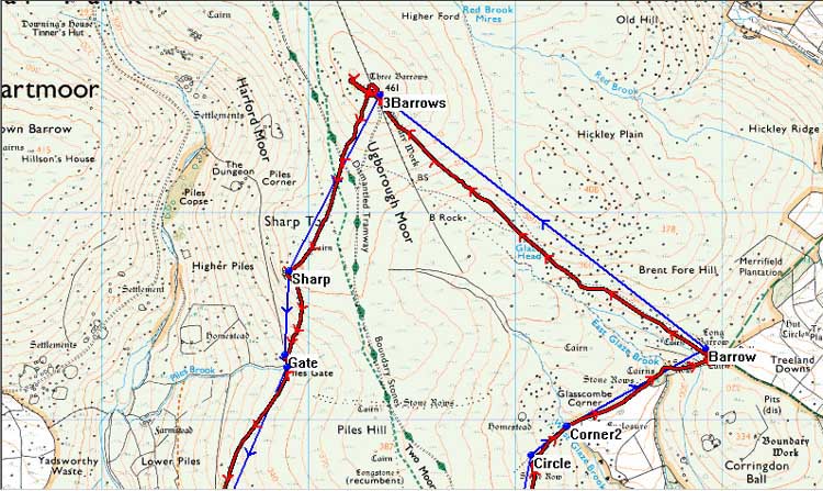
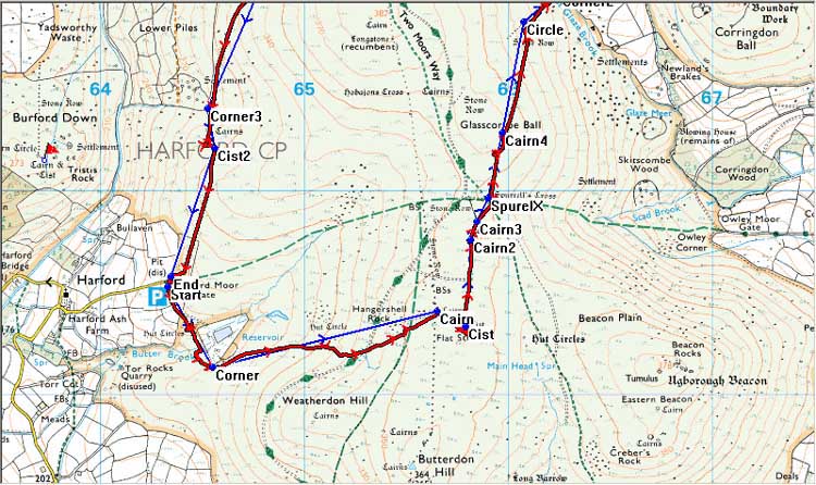
MAP: Blue = planned route, Red = GPS track of the actual walk
The blue lines are the compass or GPS bearings. The red line is the route actually walked: it deviates from the blue route so as to miss difficult ground such as clitter, bogs and thick bracken or gorse, and often to use paths or animal tracks that are not on the map.


Reproduced from Dartmoor OS Explorer map 1:25 000 scale by
permission of Ordnance Survey
on behalf of The Controller of Her Majesty's
Stationery Office.
© Crown copyright. All rights reserved. Licence number 100047373.
Also, Copyright © 2005, Memory-Map Europe, with permission
The road from Ivybridge to Cornwood is good until you enter Cornwood, then it becomes a more or less single track road, with passing places. From Cornwood, it is three miles of narrow lanes to Harford. There is a similar approach from the eastern end of Ivybridge. On entering Harford from Harford Bridge, from the Ivybridge direction, you need to turn left after the church and drive up the narrow lane and go through the gate onto the moor, parking just inside the gate, at the P symbol on the map.
Statistics
Distance - 12.4 km / 7.7 miles
Start 9.40 am, Finish 2.55 pm, Duration 5 hr 15 min
Moving average 3.7 kph / 2.3 mph; Overall average 2.3 kph / 1.4 mph
All photographs on this web site are copyright ©2007-2016 Keith Ryan.
All rights reserved - please email for permissions
Dartmoor Tick Watch
The Cornish Pasty - The Compleat Pastypaedia
