|
F11 - Full screen F11 - Normal view Home & Contents |
|
"Alt" + � |
|||
This walk: 2011-4-14. Week Ford, skylark on Horse Ford Cross, ruins of mine buildings, Hootens Wheals mine, leat, water wheel pit, willow, rowan, hawthorn. flat-rod bed, Henroost Mine, Skir Ford, "Dartmoor steppes".
This walk was more or less a repeat of the walk on 9th March 2011 except that we visited the main mine area with buddles etc. that were not seen on that walk. <<<<<
Walk details below - Information about the route etc.
Zoomed view to the Week Ford stepping stones visited on the walk on 16 Feb. 2011.
A skylark that alighted on Horse Ford Cross. The Dartmoor Crosses web site says: "One of a number of crosses that marks the route of the Monks� Path. This is the ancient name given to the track that links the Buckfast Abbey with those at Tavistock and Buckland. This path takes a more northerly route than the more commonly known Abbots� Way."
The first of the ruined buildings encountered on approaching the mine area: remains of the mine office, not a lot to see ..... this was also the mine captain's house at one time .....
Another view.
The second building is the remains of the "Barracks", where the miners slept during the week, it is also described as the "dry" where clothes could be dried.
Approaching the end of the track out to Hooten Wheals mine.
Walking along the old raised leat that carried water to a water wheel: this area was highly industrialised in the past, with a 45 foot water wheel, driving 12 Cornish stamps and 16 Californian stamps to crush the ore.
Two buddles: Geevor Mine web site explains: "A buddle was a device for concentrating tin ore. In the mid-19th century these most usually took the form of an inclined circular pit with rotating brushes; the tin from the stamps was fed into the centre or side of the pit and was graded by gravity, concentrating the heavy ore near the inlet point.
In the mid 19th Century the traditional buddle was mechanized to become the round buddle. Originating as pits in the ground with sloping floors, the job of the buddle was to take the finely crushed rock, and wash away the waste material whilst the ore settled and was dug out periodically. Buddles used the difference is density between the heavier tin particles and the lighter waste material. It was a slow and labour intensive process."
Just about the last trace of the buddle mechanism .....
This might be the old central spindle cap.
A presumed piece of military hardware, well-rusted but with a still visible firing pin mark.
A different view of the main mine area.
As previous photo.
Looking down from above the buddles.
As previous photo.
The area above the mine buildings - spoil heaps.
This photo shows the end of a metal pipe that came from the leat towards the buddles.
A last view.
One of the trees growing in the wheel pit .....
In the water wheel pit: a willow
without the long lanceolate leaves of several species: possibly a grey willow,
Salix cinerea.
:
Young flower buds and leaves of a rowan (mountain ash) tree, Sorbus aucuparia.
A very old and wizened hawthorn tree, the base of the trunk is hollow .....
Base of the hawthorn tree, Cretagus monogyna.
Walking up the bed of the flat-rod system .....
Moredetail.
Looking into the main gert of Henroost Mine.
Skir Ford.
One of the "Dartmoor steppes", a break in the ground that is approx. 18-inches deep .....
The same "steppe" showing the layers in the peat .....
Looking back up the fairly steep peaty slope where a about seven "steppes" can be seen, possibly formed by soil slippage when the soil is highly water-logged?
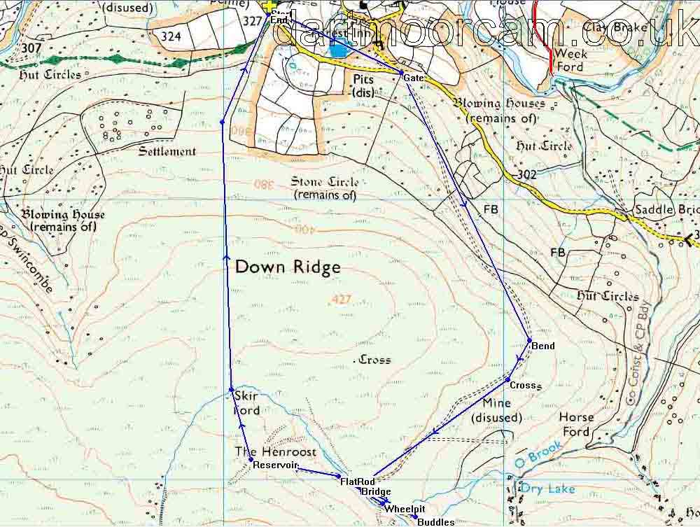
MAP: Blue = planned route of the walk.

Ordnance Survey © Crown copyright 2005. All rights reserved. Licence number
100047373.
Also, Copyright © 2005, Memory-Map Europe, with permission.
This walk was approached from the Two Bridges-Ashburton road, turning off at the Forest Inn sign near Dartmeet, passing through Hexworthy, passing the Forest Inn and turning right at the top of the hill to park just before the cattle grid. The car park is marked by the yellow cross on the map.
Statistics
Distance - 4.89 km / 3.04 miles
All photographs on this web site are copyright ©2007-2016 Keith Ryan.
All rights reserved - please email for permissions
Dartmoor Tick Watch
The Cornish Pasty - The Compleat Pastypaedia
